March 01, 2018 by Rebecca Crommelin

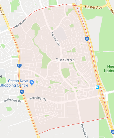
The suburb of Clarkson is an outer northern suburb of Perth, located 34 kilometres north of the Perth CBD. It is a part of the City of Wanneroo council, and is approximately 8 square kilometres in size.
The suburb was named after the Clarkson’s, a family of sheep farmers who were the first European settlers in the area. The Clarkson family held leases of land in the area since the 19th century. In fact, the ruins of the Clarksons’ original homestead are still preserved in Riverlinks Park on Connolly Drive today.
While Clarkson is mostly a residential area, it also operates as a town centre that serves many of the surrounding suburbs with it’s large number of facilities and amenities. Clarkson also has a railway station on the Joondalup railway line, making it a major public transport hub for the neighbouring suburbs.
Clarkson is roughly 2 kilometres away from the Indian Ocean and the coastlines of Quinns Beach and Claytons Beach.
In the 2011 census, the population in Clarkson was 11,689 people – a significant increase from the 7,076 people recorded in 2006. It is predicted that the population of Clarkson will continue to grow at an exponential rate, peaking at an estimated 18,645 people in 2026.
The predominant age group in the area is 0 – 14 years old, with households being mostly couples with children.
Currently, homeowners in Clarkson are likely to be repaying $1800 - $2400 per month on their home loan repayments. In 2011, 62.1% of the homes in the area were owner-occupied – compared with 67.1% in 2006.
At present, the median sales price of houses in Clarkson is $390,500. The average rent prices in the area are approximately $330 per week.
In the early 90’s, the area started to see some suburban development, with the completion of the neighbouring Mindarie Marina and residential dwellings in the area. The north-eastern portion of Clarkson was developed later in 1995, with the suburb continuing to be built throughout the 2000s, as the population grew steadily.
Somerly is a commercial and residential development area in south-east Clarkson, mainly surrounding the railway station, that was completed in 2008. This 1,800 lot community was constructed on a 162 hectare area in a partnership between the Western Australia Government Department of Housing and Works land development agency Landstart, and development company Urban Pacific. This building project aimed to create a community-within-a-community with commercial businesses, fibre-optic home internet and a landscaping package at no additional cost to new home-buyers.
The Somerly development made Clarkson one of the largest, most densely populated suburbs in Perth’s north.
In addition, a new residential coastal development was built by Satterley in 2012 called Catalina Estate, that sits within the suburbs of both Clarkson and Mindarie.
In comparison to it’s neighbouring suburbs, Clarkson is a very mixed-use area with a variety of facilities and a large retail and shopping district. The Ocean Keys Shopping Centre located on the main road of Ocean Keys Boulevard, is a major shopping mall with several major retail outlets such as Coles, Kmart, Target, JB Hi-Fi and more. There are several other commercial outlets around the shopping centre, including a post office, Bunnings Warehouse, two service stations and several car dealerships.
There is also a popular strip of restaurants and take-away dining outlets situated west of the Ocean Keys Shopping Centre. The Whale + Ale pub and restaurant is located opposite the shopping centre, on the north of Ocean Keys Boulevard. It is the only pub and main nightlife hub in Clarkson.
In addition, there are 3 medical centres in Clarkson, which include the Ocean Keys Family Practice, Clarkson Family Practice and The Somerly Central Medical Centre.
There are over 10 parks located throughout the suburb, the two main ones being Richard Aldersea Park and Anthony Waring Park in the middle of the suburb. Anthony Waring Park is the largest and includes sporting facilities. The Clarkson Youth Centre is a community centre and features BMX tracks and a skate park. There is a public library in the suburb called the Clarkson Library. The Clarkson Police Station features in the suburb and serves all the neighbouring suburbs from Butler and Jindalee to Tamala Park.
There are several educational institutions located in the suburb. Clarkson has two state primary schools that serve different parts of the suburb. Clarkson Primary School is the oldest established school and serves the western area of Clarkson, while Somerly Primary School serves the Somerly estate community in the east of Clarkson. There is also St. Andrew’s Catholic Primary School, which is a private Catholic school situated next to St. Andrew’s Catholic Church.
A large state high school, Clarkson Community High School, is also located in the suburb and was established in 1996. Given that it’s the only state high school in the area, it serves a large community of surrounding suburbs in the north. In 2010, a TAFE campus specializing in skilled trades and apprenticeships called Trades North, was built next to the high school.
If you are interested in a free RP Data report on a property in Clarkson or another suburb, call our team at Mortgage Choice Joondalup & Clarkson on (08) 9485 0090.
Click here to meet the team at Mortgage Choice in Joondalup & Clarkson
Catch up on our latest updates & tips on our blog
This suburb profile has been created using information from realestate.com.au and a suburb statistic report from CoreLogic RP Data.


